Transphoto
照片中反映的内容为事实而且目的并非为推广任何站点;所有资料由用户提交而且不能代表网站的任何政治站点。
关闭
稳城 — Trolleybus Line and Infrastructure
  稳城Trolleybus Line and Infrastructure
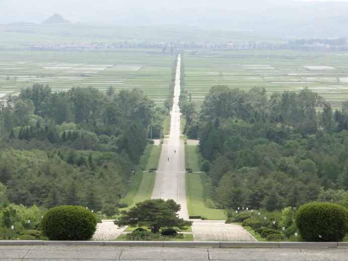
A 4 km-long bidirectional single overhead set trolleybus line between the Onsong Railway Station and the Wangjaesan Monument, photographed from the monument.
A trolleybus loop and overhead support beams are visible mounted on poles on one side of the road.
• • •
Однопутная двусторонняя троллейбусная линия длиной 4 км. между ж.д. вокзалом в городе Онсон и монументом Вынджэсан, снято от монумента.
Видны троллейбусное кольцо и кронштейны, закреплённые на столбах вдоль одной стороны дороги.

https://www.qsl.net/ah6hy/northhamgyong.html

提供照片用户: jiachen · 悉尼           日期: 16 六月 2013 年, 星期天

展示拍摄地点

照片数据

发布 07.12.2020 14:39 UTC
观看 — 1337

详细信息

EXIF

Model:DSC-HX1
Date and Time:16.06.2013 20:01
Exposure Time:1/800 sec
Aperture Value:4.5
ISO Speed:125
Focal Length:26.2 mm
展示完整EXIF

评论 · 2

07.12.2020 14:39 UTC
链接
Ymtram · 东黑文-布兰福德
照片:: 20025 · 第三方照片审查员 / 照片审查员 / 综合编辑人员 / 新闻编辑人员 / 页面翻译 (EN)
A 4 km-long bidirectional single-wire-set trolleybus line between the Onsong Railway Station and the Wangjaesan Monument to to the northeast of the city. The installation's likely intent is for the purpose of delivering visitors to the monument. According to an verified source the line likely opened in 1996. The line is most likely mothballed from at least 2004 (or earlier), but nevertheless maintained in decent condition.

Assumed route:
https://www.google.com/maps/dir/42.95340...4m1!3e0

Additional photos with the one-way overhead clearly visible:
https://abandonedkansai.files.wordpress....rea.jpg
https://abandonedkansai.files.wordpress....prk.jpg
Photos by Abandoned Kansai.

The above photos are made from the Onsong hotel, located here:
https://goo.gl/maps/nGZbioDPy6TevD3x9

• • •

Однопутная троллейбусная линия длиной 4 км. между ж.д. вкозалом в городе Онсон и монументом Вынджэсан к северо-востоку от города. Линия вероятнее всего используется для подвозки посетителей к монументу. Согласно неподтверждённому источнику, линия предположительно открыта в 1996 г. Линия предположительно законсервирована, как минимум, начиная с 2004 г. (или ранее), но при этом поддерживается в адекватном состоянии.

Предположительная трасса:
https://www.google.com/maps/dir/42.95340...4m1!3e0

Фотографии с односторонней КС крупным планом:
https://abandonedkansai.files.wordpress....rea.jpg
https://abandonedkansai.files.wordpress....prk.jpg
Автор фотографий Abandoned Kansai.

Фотографии выше сделаны от гостиницы в Онсоне, расположенной здесь:
https://goo.gl/maps/nGZbioDPy6TevD3x9
+3
+3 / –0
15.05.2024 16:06 UTC
链接
Bulat Gabitov · 喀山
照片:: 2
А троллейбусы там где хранятся тогда? Не нашёл информации о наличии депо, ну или отстоя самих троллейбусов
0
+0 / –0

你的评论

请勿讨论政治话题;封禁时期≥1月
登录的用户才能写评论.