Transphoto市区电力交通网

Maps and Plans

波士顿

2305 kB
2
2424

四月 2013 年
作者: Павел С

311 kB
2
1233

Схема первой подземки США с датами открытия. Public Domain. Источник: http://en.wikipedia.org/wiki/File:Tremont_Street_Subway.jpg

2005 年
提供照片用户: Palal

424 kB
712

1965 年
提供照片用户: Palal

129 kB
420

Eastern MassachusettsMaps

Eastern Massachusetts

Copps Hill Freight Terminal

Electric Railway Journal, volume 42, number 7 (8/16/1913), page 260

1913 年
提供照片用户: AlexSan

253 kB
296

Plan of Causeway Street Station adjacent to the North Union Station

Electric Railway Journal, volume 41, number 10 (3/8/1913), page 410

1913 年
提供照片用户: AlexSan

290 kB
1
331

Plan of track layout at Sullivan Square Station

Electric Railway Journal, volume 41, number 9 (3/1/1913), page 360

1913 年
提供照片用户: AlexSan

918 kB
604

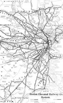
Map of the Boston Elevated Railway Co. system

Electric Railway Section of the Commercial & Financial Chronicle, v. 87, no. 2257 (9/26/1908), p. 11

1908 年
提供照片用户: AlexSan

173 kB
368

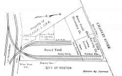
New Sullivan Square elevated storage yard of the Boston Elevated Railway
Street Railway Journal, vol. 30, no. 21 (11/23/1907), page 1028

十一月 1907 年
提供照片用户: AlexSan

430 kB
271

Map of the Boston, showing lines of the West End Street Railway Co.

Street Railway Journal, volume 11, number 4 (4/1895), page 209

1895 年
提供照片用户: AlexSan


现在显示的照片: 9/9 张
最新照片.